See also: Creating a new Placemark
A geographic location defined by longitude, latitude, and an optional altitude respectively. When a Point is contained by a Placemark, the point itself determines the position of the Placemark's name and icon. When a Point is extruded, it is connected to the ground with a line. This "tether" uses the current Line Style.
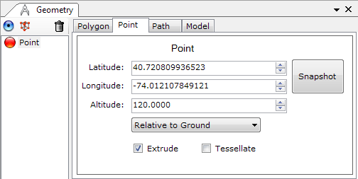
A single tuple consisting of floating point values for longitude, latitude, and altitude (in that order). Longitude and latitude values are in degrees, where:
Specifies how the Altitude is interpreted. Possible values are:
Specifies whether to connect the point to the ground with a line. To extrude a Point, the value for Altitude mode must be either Relative to Ground or Absolute, and the altitude component within the coordinates string must be greater than 0 (in the air). The point is extruded toward the center of the Earth's sphere.
Tessellate
Specifies whether to allow the geometry to follow the terrain elevation.